How to deal with GPS data to give direction or a specific path ?

Status
Not open for further replies.

Bazziil

Member
Hi everyone,
I want a system that uses GPS data to create paths, obstacles and similar things. Do you know any libraries or documentation that will allow me to do that?

For example :
- Get a pair of coordinates (x, y)
- Transform it into a specific order.
- Give an order to my system : "Go North", "Move to this line" or "Move this way but don't go there"

The first thing to realize is that a GPS doesn't do direction of motion well unless it is moving at a significant speed. If your system is an aircraft, that is usually not a problem because if it stops moving it falls out of the sky. If this is a boat or land vehicle, the need to have motion to determine direction places limits on the precision of your tracking.

I'm not sure what you mean by "create paths, obstacles, and similar things". Are you going to create the paths from the GPS Data? How do you create obstacles? By moving until you run into something, then recording data that says "Obstacle Here"?? For an aircraft, that would probably be the last data you record! ;-)
 
You'll need to create a map - I doubt there is a ready to use Arduino library, as this subject can be quite complicated.
It's independend from GPS.
 
Hi everyone,
I want a system that uses GPS data to create paths, obstacles and similar things. Do you know any libraries or documentation that will allow me to do that?

For example :
- Get a pair of coordinates (x, y)
- Transform it into a specific order.
- Give an order to my system : "Go North", "Move to this line" or "Move this way but don't go there"

Bazziil:

A few years back, as our amateur radio club refined the electronics packages that we launched via a weather balloon (up to 100,000 feet), we found it very valuable to test everything as best we could before actually sending it to space & back. Testing devices that changed their operations based upon GPS data (balloon release, power control on the beacon transmitter, snapshot camera, etc.) was the most difficult. I wrote a program for the Arduino that generated GPS-formatted serial data streams which simulated data that "semi-randomly wandered" within a circle, where the tester could set the radius of the bounding circle, the location of the circle center pin, the maximum degrees change in bearing, the rise/fall rate of the altitude, & the high/low limits of the speed & altitude. I don't know your specific application prompting your request, but maybe you could start with this capability & add your "exclusion zones" (obstacles), your "target zones" (destinations), & the calculations & processing necessary to generate GPS data that behaves as you desire. The program that I wrote is available from my Google drive <here>.

Good luck & have fun !!

Mark J Culross
KD5RXT
 
Thank you all for your answer, in fact your answers hovers almost everything that i want =)
- My application is for a vehicle that will probably have a map.
- And from this map i want to create pathways, obstacles and more. I will have an application that will allow me to configure all of this.
- I will also get data from an inertial control unit, that will give me the direction that my vehicle is aiming for.

I'm not sure what you mean by "create paths, obstacles, and similar things". Are you going to create the paths from the GPS Data? How do you create obstacles? By moving until you run into something, then recording data that says "Obstacle Here"?? For an aircraft, that would probably be the last data you record! ;-)
By obstacles, i mean "Forbidden zone" or an area where the vehicle cannot go.

You'll need to create a map - I doubt there is a ready to use Arduino library, as this subject can be quite complicated.

That's what i will probably end up doing, i didn't find any library which was unanimously approved. It's probably an easy thing, but i can't figure out how you can create a map on a software.

Thanks @kd5rxt-mark for your code, it helps me see how you can manage coordinates and that's a great basis to begin with !

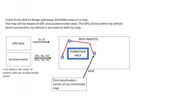
To sums up :
- I will probably create a map where the center will be based on the first coordinates.
- On this map, i will design forbidden areas or pathways.
- Then i will have to determine the vehicle trajectory based on the map data.
- Give orders to the motors in order to follow the trajectory "Go left", etc ...

Now my main issue is how to create a map and how do you manage it ?

PS : How can you link pictures in this forum ? It will be easier for me to explain my point of view and what i want.
 
If you hover of edit bar icons one shows : 'Insert image'

Clicking that will allow selecting a file from disk: png or jpg ae common and size is limited to about 1 MB - images over that size will give some odd error about failing to upload, not saying exactly why.
 
Thank you, i wasn't in the main site that's why i couldn't find the edit option.
Here is a summary of my issue, i hope it's clearer than my explanations :
map coordonnees.jpg
 
I faced similar issues about 5 years ago when I built a Robo-Boat to do depth surveys of lakes with an onboard depth sounder. I eventually developed software to have the boat do a raster scan with 5-10m line spacing over a lake. I entered the boundaries of the lake by generating a perimeter on Google Earth and saving that perimeter as a KML file. I wrote a pC application to extract the corner points from the KML file as Latitude and longitude pairs and passed that to the boat which checked its position against the perimeter and stayed inside the perimeter by about 5 meters. I still got my boat hung up on a snag that had fallen into the lake after the Google Earth photo was taken---but that's life in the real world!

I think you could do a similar thing by using Google Earth to get Lat/Lon coordinates of your exclusion zones. I suspect that in most of the US, the Google Earth photos have resolutions comparable to GPS position resolution (1 to 3 meters in areas where WAAS (Wide-Area Augmentation System) is available. I can definitely see the 1-meter wide path from my house to my barn on Google Earth. Whether that will be possible in your area of interest depends on the quality of the aerial photos Google has digitized for your area.
 
Status
Not open for further replies.
Back
Top