XRAD
Well-known member
XRAD'S Teensy 3.6 How to read write to SD x/y integer coord pairs?
Hello,
I have a GPS point set which is converted to x/y points (integers) for tft pixel display. I have the display points showing up just fine for a walk around the area within the bounds of my TFT 'map.' But when I want to scale the pixel points to a larger area (zoom in or zoom out), I will need to redraw all the current points and display the new 'map' of pixels at selected 'scale.'
I 'think' that I have to save the points to SD in order to redraw them (otherwise, I will only have the currently calculated x/y point pair to draw)
However! I am trying to save an 'unknown' quantity of x/y integer pair points to the SD (unknown because I may walk for 1 minute, or one hour, and the points set may need to be stored via an adaptive array (vector array?). Then, if I scale the map up or down, all the points saved would be redrawn to a TFT at the chosen scale (basically zoom in/zoom out )
1) So...is this the best strategy?
2) How do I save a dynamic/variable sized array of 'pairs'?
2) and how do I recall them in 'pairs' and display them all to the TFT as a group?
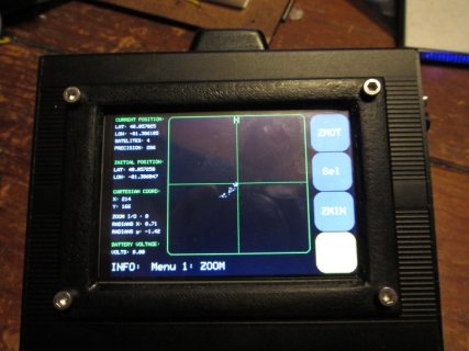
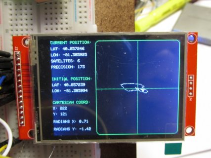
Thank you for any tips!! Pic of a live display of plotted points at base scale.... (accuracy meters to pixels is NOT required)
here is my code so far:
Hello,
I have a GPS point set which is converted to x/y points (integers) for tft pixel display. I have the display points showing up just fine for a walk around the area within the bounds of my TFT 'map.' But when I want to scale the pixel points to a larger area (zoom in or zoom out), I will need to redraw all the current points and display the new 'map' of pixels at selected 'scale.'
I 'think' that I have to save the points to SD in order to redraw them (otherwise, I will only have the currently calculated x/y point pair to draw)
However! I am trying to save an 'unknown' quantity of x/y integer pair points to the SD (unknown because I may walk for 1 minute, or one hour, and the points set may need to be stored via an adaptive array (vector array?). Then, if I scale the map up or down, all the points saved would be redrawn to a TFT at the chosen scale (basically zoom in/zoom out )
1) So...is this the best strategy?
2) How do I save a dynamic/variable sized array of 'pairs'?
2) and how do I recall them in 'pairs' and display them all to the TFT as a group?
Thank you for any tips!! Pic of a live display of plotted points at base scale.... (accuracy meters to pixels is NOT required)
here is my code so far:
Code:
#include <SD.h>
#include <TinyGPS.h>
#include <Adafruit_GFX.h>
#include "Adafruit_ILI9341.h"

#define TFT_CS    8      // TFT CS  pin is connected to arduino pin 8
#define TFT_RST   9      // TFT RST pin is connected to arduino pin 9
#define TFT_DC    10     // TFT DC  pin is connected to arduino pin 10

// initialize ILI9341 TFT library
Adafruit_ILI9341 tft = Adafruit_ILI9341(TFT_CS, TFT_DC, TFT_RST);

TinyGPS gps;

bool  oneTimePosition = true;
int long oneTimeLat, oneTimeLong;

unsigned long startMillis;
unsigned long currentMillis;
const unsigned long period = 1000;

#define  R 6367000 // Radius earth in m

int long x ;
int long y ;
int long homex;
int long homey;
int long homeX;
int long homeY;

int centeredX;
int centeredY;

int dx;
int dy;

//not used yet
#define MAP_WIDTH 210
#define MAP_HEIGHT 240
#define MAP_CENTERX 215
#define MAP_CENTERY 120
#define width 210
#define height 240


File myFile;

/*
  void drawCross() {//draw a solid cross
  tft.drawFastVLine(215, 0, 240, ILI9341_GREEN);
  tft.drawFastHLine(110, 120, 210, ILI9341_GREEN);
  }
*/

void drawMap() { //draw a map w/dotted cross
  tft.drawRoundRect(110, 0, 210, 240, 10, ILI9341_GREEN);
  for (int x = 55; x < 160; x++) {
    tft.drawPixel((2 * x), 120, ILI9341_GREEN);
  }
  for (int y = 0; y < 120; y++) {
    tft.drawPixel(215, (2 * y), ILI9341_GREEN);
  }
  tft.setCursor(210, 2);
  tft.fillRect(210, 2, 10, 14, ILI9341_BLACK);
  tft.setTextColor(ILI9341_GREEN);  tft.setTextSize(2);
  tft.println("N");
}


void setup()
{
  Serial.begin(115200);
  Serial1.begin(9600);//my GPS device uses 9600 baud, using teensy Serial1

  Serial.print("Initializing SD card...");

  // see if the card is present and can be initialized:
  if (!SD.begin(BUILTIN_SDCARD)) {
    Serial.println("Card failed, or not present");
    // don't do anything more:
    return;
  }
  Serial.println("card initialized.");

  myFile = SD.open("test.txt", FILE_WRITE);

  // if the file opened okay, write to it:
  if (myFile) {
    Serial.print("Writing to test.txt...");
    myFile.println("testing 1, 2, 3.");
    // close the file:
    myFile.close();
    Serial.println("done.");
  } else {
    // if the file didn't open, print an error:
    Serial.println("error opening test.txt");
  }

  // re-open the file for reading:
  myFile = SD.open("test.txt");
  if (myFile) {
    Serial.println("test.txt:");

    // read from the file until there's nothing else in it:
    while (myFile.available()) {
      Serial.write(myFile.read());
    }
    // close the file:
    myFile.close();
  } else {
    // if the file didn't open, print an error:
    Serial.println("error opening test.txt");
  }

  tft.begin();
  tft.setRotation(3);
  tft.fillScreen(ILI9341_BLACK);
  tft.setCursor(40, 100);
  tft.setTextColor(ILI9341_WHITE);  tft.setTextSize(3);
  tft.println("GPS ACTIVATED");

  delay(2000);
  tft.fillScreen(ILI9341_BLACK);

  tft.setCursor(0, 0);
  tft.setTextColor(ILI9341_GREEN);  tft.setTextSize(1);
  tft.print("CURRENT POSITION: ");
  tft.setCursor(0, 90);
  tft.print("INITIAL POSITION: ");
  tft.setCursor(0, 150);
  tft.print("CARTESIAN COORD: ");

  drawMap();

  startMillis = millis();
  delay(5000);//allow GPS power up
}


void loop()
{
  bool newData = false;
  unsigned long chars;
  unsigned short sentences, failed;

  // For one second we parse GPS data and report some key values
  for (unsigned long start = millis(); millis() - start < 1000;)
  {
    while (Serial1.available())
    {
      char c = Serial1.read();
      // Serial.write(c); // uncomment this line if you want to see the GPS data flowing
      if (gps.encode(c)) // Did a new valid sentence come in?
        newData = true;
    }
  }

  if (newData) {


    float flat, flon;
    unsigned long age;
    gps.f_get_position(&flat, &flon, &age);
    //Serial.print("LAT=");
    //Serial.print(flat == TinyGPS::GPS_INVALID_F_ANGLE ? 0.0 : flat, 4);
    //Serial.print(" LON=");
    //Serial.print(flon == TinyGPS::GPS_INVALID_F_ANGLE ? 0.0 : flon, 4);
    //Serial.print(" SAT=");
    //Serial.print(gps.satellites() == TinyGPS::GPS_INVALID_SATELLITES ? 0 : gps.satellites());
    //Serial.print(" PREC=");
    //Serial.println(gps.hdop() == TinyGPS::GPS_INVALID_HDOP ? 0 : gps.hdop());

    tft.fillRect(20, 15, 90, 10, ILI9341_BLACK);
    tft.setCursor(0, 15);
    tft.setTextColor(ILI9341_WHITE);  tft.setTextSize(1);
    tft.print("LAT: ");
    tft.println(flat == TinyGPS::GPS_INVALID_F_ANGLE ? 0.0 : flat, 6);

    tft.fillRect(20, 30, 90, 10, ILI9341_BLACK);
    tft.setCursor(0, 30);
    tft.setTextColor(ILI9341_WHITE);  tft.setTextSize(1);
    tft.print("LON: ");
    tft.println(flon == TinyGPS::GPS_INVALID_F_ANGLE ? 0.0 : flon, 6);

    //record initial home position and display data on tft
    if (oneTimePosition == true)  {
      tft.setCursor(0, 105);
      tft.setTextColor(ILI9341_WHITE);  tft.setTextSize(1);
      tft.print("LAT: ");
      tft.println(flat, 6);
      tft.setCursor(0, 120);
      tft.print("LON: ");
      tft.println(flon, 6);

      float radiansX = ( flat * (asin(1)) / 90 );
      float radiansY = ( flon * (asin(1)) / 90 );
      //Serial.print("radians x:  ");
      //Serial.println(radiansX);
      //Serial.print("radians y:  ");
      //Serial.println(radiansY);

      homex = R * radiansY * cos(radiansX);
      homey = R * radiansX;

      //Serial.print("homex:  ");
      //Serial.println(homex);
      //Serial.print("homey:  ");
      //Serial.println(homey);

      //tft.drawPixel( homex, homey, ILI9341_WHITE);//draw home pixel
      oneTimePosition = false;
    }

    float radiansX = ( flat * (asin(1)) / 90 );
    float radiansY = ( flon * (asin(1)) / 90 );

    //Serial.print("radians new x:  ");
    //Serial.println(radiansX);
    //Serial.print("radians new y:  ");
    //Serial.println(radiansY);

    x = R * radiansY * cos(radiansX);
    y = R * radiansX;


    if (homex != x) {
      dx = (x - homex);
      dx = dx + 215;
    }

    if (homey != y) {
      dy = (y - homey)  ;
      dy = -dy + 120;//reverse N/S here
    }

      //record x/y data pairs to SD here?

    //draw the newest x,y coord pixel every second
    tft.drawPixel( dx, dy, ILI9341_WHITE);

    Serial.print("x coord pixel:  ");
    Serial.println(dx);
    Serial.print("y coord pixel:  ");
    Serial.println(dy);
    Serial.println("");

    //clear radians tft X Y ...
    tft.fillRect(60, 200, 40, 40, ILI9341_BLACK);
    tft.setCursor(0, 200);
    tft.setTextColor(ILI9341_WHITE);  tft.setTextSize(1);
    tft.print("RADIANS X: ");
    tft.println(radiansX);
    tft.setCursor(0, 220);
    tft.print("RADIANS Y: ");
    tft.println(radiansY);

    //update and show current X Y ...
    tft.fillRect(10, 165, 90, 30, ILI9341_BLACK);
    tft.setCursor(0, 165);
    tft.setTextColor(ILI9341_WHITE);  tft.setTextSize(1);
    tft.print("X: ");
    tft.println(dx);
    tft.setCursor(0, 180);
    tft.setTextColor(ILI9341_WHITE);  tft.setTextSize(1);
    tft.print("Y: ");
    tft.println(dy);

    //update and show precision and satellites
    tft.fillRect(60, 45, 40, 10, ILI9341_BLACK);
    tft.setCursor(0, 45);
    tft.setTextColor(ILI9341_WHITE);  tft.setTextSize(1);
    tft.print("SATELITES: ");
    tft.println(gps.satellites());
    tft.fillRect(60, 60, 40, 10, ILI9341_BLACK);
    tft.setCursor(0, 60);
    tft.setTextColor(ILI9341_WHITE);  tft.setTextSize(1);
    tft.print("PRECISION: ");
    tft.println(gps.hdop());
  }
}
Attachments
Last edited: